On June 28-30, 2013, my friends and I hiked to the summit of Mount Whitney via its most popular route, the Mount Whitney Trail. The total distance was 21.4 miles with an elevation gain of 6,145 ft (1,873 m). We started the hike at the Whitney Portal at an elevation of 8,360 ft (2,548 m), camped overnight at Trail Camp at 12,000 ft (3,658 m), reached the summit the next day at 14,505 ft (4,421 m), then hiked all the way back to Whitney Portal.
 |
| Paul, Vi, Mike and me at Mount Whitney summit, June 2013 |
 |
| Roman at Mount Whitney summit, June 2013 (Photo by Roman Racela) |
Roman, our leader, was awarded a permit that he reserved online at www.recreation.gov with a June 29 entry date. Each of us paid $15 for the permit. Paul reserved our campsites at the Whitney Portal Campground (Mt. Whitney Family Campground) through the same website. The campground fee was $28 per night. Before the trip, we as a group did a few hikes in various local trails, and camped overnight at the White Mountains in Bishop, CA a weekend before the trip. You may click here to read how I trained for this summit hike.
Paul and I drove on Thursday night, while the rest of our friends Roman, Vi, and Mike drove on Friday. We took US-395 north to Lone Pine, CA and arrived at the Whitney Portal Campground, elevation 8,360 ft (2,548 m), at 11 p.m. The reserved campsites were labeled so we did not have a hard time finding ours. That night, the temperature felt like it was in the mid-70s. Aside from the sound of the nearby creek, the campground was quiet.
Friday, June 28th: To Whitney Portal, elevation 8,360 ft (2,548 m)
 |
| Whitney Portal Campground |
 |
| WAG Bags issued by US Forest Service |
 |
| Day hike to Lone Pine Lake |
 |
| One of several creeks |
 |
| Cool water from creek |
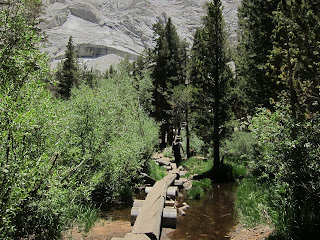 |
| Logged segment of Mount Whitney Trail |
 |
| Boulders at Lone Pine Lake |
Since we were staying at a different campsite later that night, we broke camp and packed everything after breakfast. We then drove down to Lone Pine to get our permit and WAG Bags at the Eastern Sierra Interagency Visitor Center. Besides giving us the permit and other pertinent information about hiking to Mt. Whitney, the park ranger also gave us a few helpful tips such as places where we can go to acclimatize, or take a shower for $5, or rent a bunk space for $25 per night, etc. The most important warning though was to make sure that we do not leave our WAG Bags at the campgrounds or the trailside.
We then drove back up to the campground, where our campsite for the second night was already available. Again, we pitched our tent and put all food and toiletries away in the bear box. Then, we got ready to day hike up to Lone Pine Lake while waiting for our friends. Lone Pine Lake, at an elevation of 10,000 ft (3,048 m), was a 2.6-mile hike from the trailhead. The parking spaces at the trailhead were plenty; there was also an overflow parking lot. There was a restroom, trash and recycle bins, human waste disposal bins, and bear boxes where anyone could leave extra food and toiletries. There was also a weighing scale.
It was midday when we started our day hike. The temperature felt like it was in the mid-80s. We maintained a leisurely pace; this was our only chance to hike this stretch of the trail with just a daypack and probably to see it in daylight, enjoy the view, and take pictures. Though the trees provided shade most of way, it was still hot and dusty, and got hotter the higher we hiked. Several creeks flowed across the trail and the waters remained icy cool no matter how hot it got. Each time we crossed a creek we soaked our buffs and bandana to help us cool down.
For this day hike, I wore a cap, sunglasses, buff, sleeveless shirt, lightweight hiking shorts, trekking socks, sock liners, and hiking shoes. In my daypack, I had a 3L water reservoir and snacks. I also brought my phone, camera, headlamp and knife.
On the trail, we met many groups of people of varying fitness levels and activities- trail runners, day hikers, and backpackers. We also met a couple of park rangers equipped for a few days in the mountains. Although it was not crowded on the trail, you could tell it was peak hiking season on Mt. Whitney.
At Lone Pine Lake we cooled down, ate our snacks, relaxed and admired the scenery. We then headed down, not taking as much time as we had on the way up. By then, we knew our friends had arrived and were settling in at the camp. After meeting up with them, we drove back down to Lone Pine to have an early group dinner. On the drive down, storm clouds were forming over the mountain range, but it didn’t rain where we were. When we got back to the Whitney Portal campground, it felt like it was in the mid-90s so we had to keep our tent vestibules open. Due to anticipation and heat, I didn’t sleep very well.
 |
| View of White Mountains from Mount Whitney Trail |
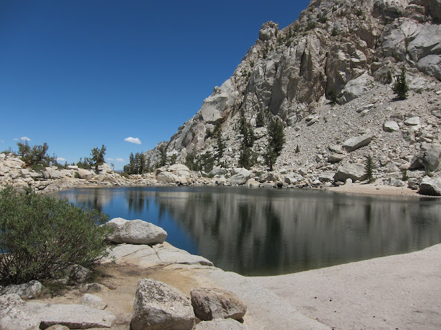 |
| Lone Pine Lake |
Saturday, June 29th: To Trail Camp, elevation 12,000 ft (3,658 m)
 |
| Whitney Portal parking lot |
 |
| Mount Whitney trailhead |
 |
| First Light |
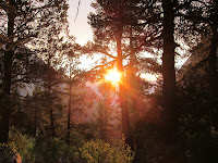 |
| Sunrise |
 |
| Early morning light |
 |
| 'Selvie' using iPhone |
The temperature was in the mid-60s when we started the hike. I had a headlamp- which I turned off before sunrise to save on batteries, a lightweight long-sleeved shirt- which I removed once I got warmed up, a T-shirt, a pair of lightweight hiking pants that I could roll up, trekking socks, sock liners and my hiking shoes. This time, I used trekking poles and I had a multi-day pack.
 |
| Entering Whitney Zone |
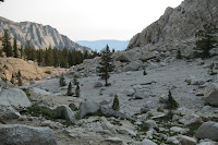 |
| Landscape above Lone Pine Lake |
 |
| Trail after entering Whitney Zone |
 |
| Picture taking at meadow |
 |
| Approaching Outpost Camp |
 |
| Mirror Lake |
 |
| Group picture at the meadow |
 |
| Above tree line |
 |
| Sierra Nevada mountain range |
 |
| Approaching Trailside Meadow |
 |
| Trailside Meadow |
Trail Camp, at an elevation of 12,000 ft (3,658 m) and 6 miles from the trailhead, was not a welcoming place, though there were many people. We pitched our tent near the lake to the right of the trail, and as close as we could get to the switchbacks going to up to Trail Crest. In hindsight, this was a lucky spot as it was very visible. The more visible the spot was, the lesser the chance of finding human waste under a rock.
 |
| Our tents at Trail Camp |
 |
| Misery at Trail Camp |
 |
| Marmot |
From Trail Camp, we could see hikers coming down the switchbacks from Trail Crest, some as late as 8 pm when we turned in. With the number of people, I could imagine how busy the trails must have been. Some of them are day hikers who started as early as 2 a.m. from the Whitney Portal. One lady we talked to told us there were 12 of them in her group but they got scattered, and a few had to turn around.
The park ranger came by, checked our permits, and made sure everyone had their WAG Bags. He said that marmots do not go after human waste or toiletries, only food. We left our bear canisters outside our tents before we turned in to prevent the marmots from sneaking into our tents. It was difficult to find a private spot to use the WAG Bag so I waited until it was dark. Though I was tired that night I was not sleepy at all.
Summit day. We were on our way by 3 a.m. Several groups already passed our tents earlier. I was feeling both hot and cold when we started. And since I normally get cold easily, I had on a fleece cap with my headlamp over it, long-sleeved base layer top, mid-layer puffer jacket, a pair of long underwear bottoms, lightweight shell pants, trekking socks, sock liners, and my hiking shoes. I had my trekking poles and in my daypack, I had my reservoir, water bottle, snacks, camera, lightweight balaclava, windbreaker, gloves, cap, and sunglasses. We left the rest of our stuff at Trail Camp: our bear canisters were a few feet from our tents, while our backpacks were inside the tents as added weights in case the wind picked up. We left the tent doors unzipped so the marmots would not tear them open if they felt like going inside.
From Trail Crest, the trail sloped down before going back up. There were no switchbacks from there, but a continuous trail to the summit at the western side of the peaks. It was very rough terrain, with the trail consisting of rocks of all shapes and sizes. At this point, I just held both my trekking poles in one hand. There were a few patches of snow near the summit, but none that required crampons. The view was stunning especially at sunrise.
Our group reached the summit at different times, and we also descended at different times. The view was great especially in the early morning light, but somehow I was more amazed by the rocks at the summit. It was extraordinary. It was not as windy there as I expected.
After taking several pictures, we headed down. On the way down, we peeled off layers of our clothing as the sun came up. We stuffed our cold weather gear back in our packs and took out our sunglasses and caps. There was more traffic on the trail by then, but I could tell there were fewer hikers than the previous day.
When we got back to Trail Camp, it was miserably hot. We packed our stuff and found out that a marmot indeed visited our tent and left a souvenir: a stinky puddle of pee on one of our sleeping pads.
There were very few hikers that came to Trail Camp that day, which meant most people probably hike to the summit on a Saturday. Compared to the crowd the previous day, the trail felt deserted most of the way down- that was lucky since I could hear flies hovering around the used WAG Bag that I tied to the outside of my pack. Expectedly, the downhill hike soon became tedious. It was this leg of the hike that I dreaded most of all. Thanks to the trekking poles though, the impact to my knees was reduced. Back at the trailhead, I weighed my pack again including all trash: my pack only got lighter by 3-lbs.
It was an enjoyable trip. I was glad there were no accidents and injuries, and that everyone in our group had fun, made it to the summit, and made it back safely. I was very thankful to be able to enjoy this hike to the summit of Mount Whitney.
Some photos taken by Paul Rojas. Used with permission.
http://facebook.com/ |
| Trail Camp |
Sunday, June 30th: To Mt. Whitney summit, elevation 14,505 ft (4,421 m)
 |
| Summit day early start |
 |
| Trail Crest |
 |
| Trail at western side of ridge |
 |
| Summit in sight |
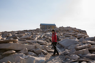 |
| Approaching summit |
 |
| Mike, Vi, Paul at Mount Whitney summit |
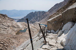 |
| Cables section of Mount Whitney Trail |
From Trail Camp to summit, the only water source was a spring flowing down the switchbacks. These switchbacks were very well maintained, though I only noticed that on the hike down in full daylight. There were snow patches here and there, but the most I saw were at the cables section. I got warm and cold at the same time because there were parts of the trail more exposed to the wind so I was constantly zipping and unzipping my jacket. The higher we got, the stronger the wind became. When we reached Trail Crest, elevation 13,600 ft (4,145 m) at 5 a.m., I put on my balaclava and gloves. Some hikers only had light shorts and puffer jackets on, but I knew my body could not withstand the wind chill for too long.
From Trail Crest, the trail sloped down before going back up. There were no switchbacks from there, but a continuous trail to the summit at the western side of the peaks. It was very rough terrain, with the trail consisting of rocks of all shapes and sizes. At this point, I just held both my trekking poles in one hand. There were a few patches of snow near the summit, but none that required crampons. The view was stunning especially at sunrise.
Our group reached the summit at different times, and we also descended at different times. The view was great especially in the early morning light, but somehow I was more amazed by the rocks at the summit. It was extraordinary. It was not as windy there as I expected.
After taking several pictures, we headed down. On the way down, we peeled off layers of our clothing as the sun came up. We stuffed our cold weather gear back in our packs and took out our sunglasses and caps. There was more traffic on the trail by then, but I could tell there were fewer hikers than the previous day.
When we got back to Trail Camp, it was miserably hot. We packed our stuff and found out that a marmot indeed visited our tent and left a souvenir: a stinky puddle of pee on one of our sleeping pads.
There were very few hikers that came to Trail Camp that day, which meant most people probably hike to the summit on a Saturday. Compared to the crowd the previous day, the trail felt deserted most of the way down- that was lucky since I could hear flies hovering around the used WAG Bag that I tied to the outside of my pack. Expectedly, the downhill hike soon became tedious. It was this leg of the hike that I dreaded most of all. Thanks to the trekking poles though, the impact to my knees was reduced. Back at the trailhead, I weighed my pack again including all trash: my pack only got lighter by 3-lbs.
It was an enjoyable trip. I was glad there were no accidents and injuries, and that everyone in our group had fun, made it to the summit, and made it back safely. I was very thankful to be able to enjoy this hike to the summit of Mount Whitney.
 |
| Me at Mount Whitney summit |
Some photos taken by Paul Rojas. Used with permission.
http://
No comments:
Post a Comment